Start Ref: 527 389
End Ref: 513 311
Distance: 8.5 miles
Time: 5.5hrs
A Walk Requiring a Shuttle Run (two cars needed).
Note: At one point on this walk, we pass under electrical pylons. For those with medical conditions that can be triggered by these, please beware. We also have the main railway tracks to cross, as well as the main road heading to Penzance – care needs to be taken.
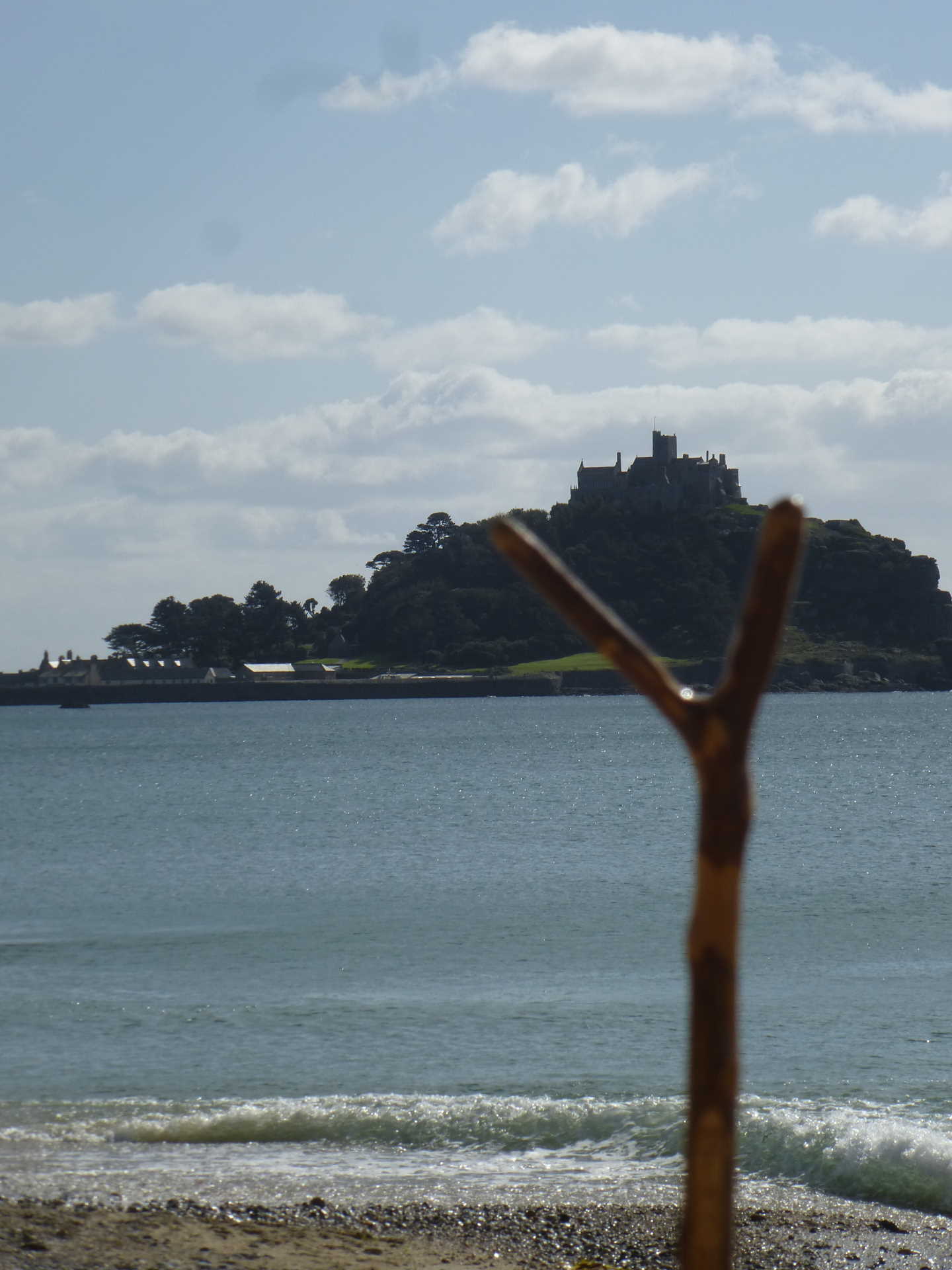
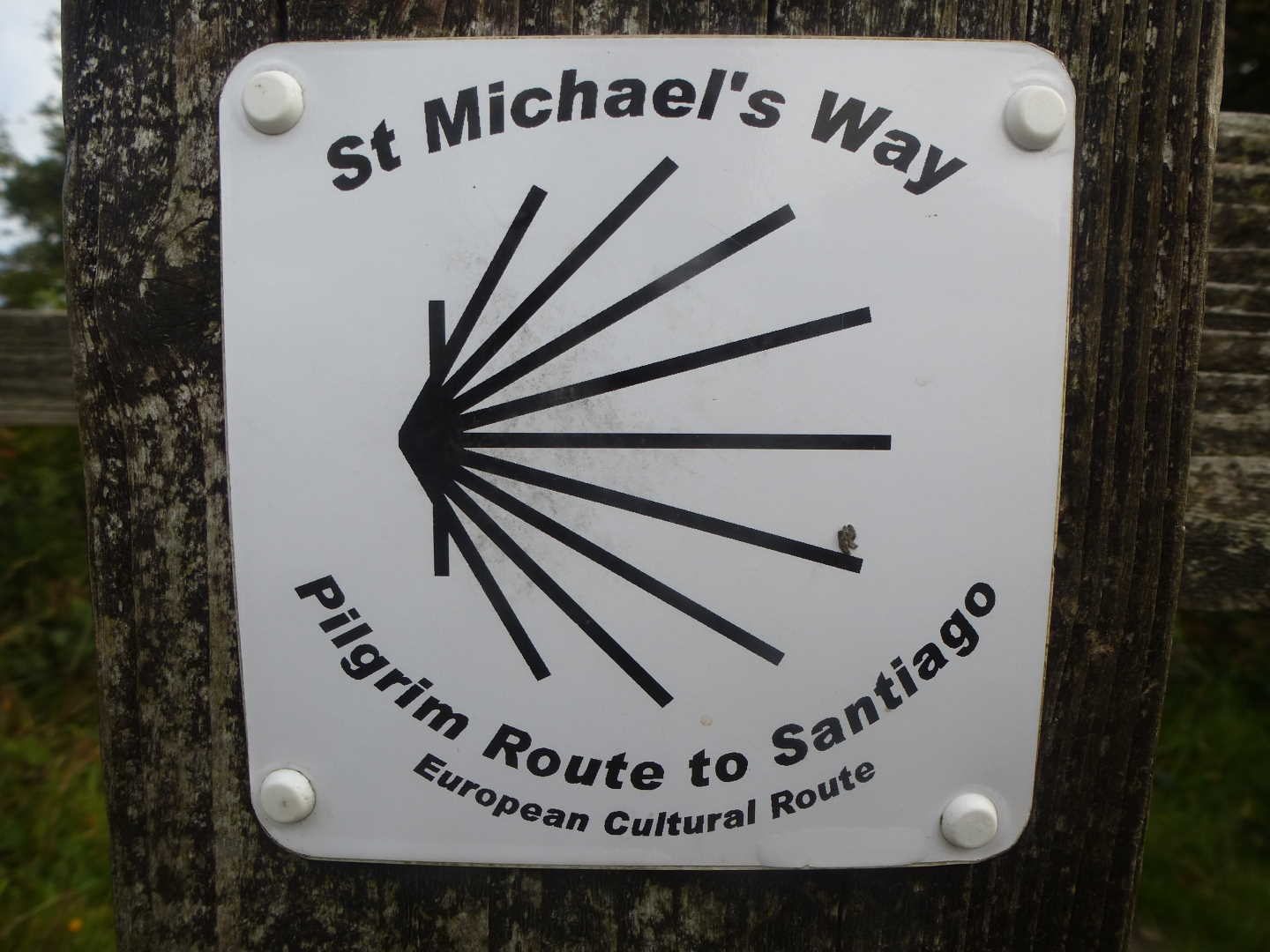
This walk takes us from the North Coast golden beaches of Carbis Bay, across green fields and down country lanes alongside the impressive Knill's Monument, to the fortified heights of Trencrom Hill past the beautiful church at Ludgvan and through the RSPB Nature Reserve of Marazion Marshes to finish on the South Coast at Marazion, with the added bonus, that at one spot – if we stand in just the right position – we can see St. Michael's Mount, Knill's Monument and Roger's Folly! In effect we will be following one of Britain's official Pilgrimage Routes .. The St. Michaels Way which gives us the additional aid of being well signposted. For the purpose of this walk, I am starting at Carbis Bay and intending to have lunch on the summit of Trencrom, before heading on towards Marazion and finishing my day with a cup of tea whilst admiring St. Michael's Mount.
Leaving a car in the carpark down by Barrepta Cove/Carbis Bay we head up the steps between the newly built hotel accommodations so that we can join the coastal path that would (if we continued on it) lead us to St. Ives. The path leads us over the footbridge that crosses (arguably) the most attractive train route in Cornwall, before bearing right and heading gently up, until we find a path off to our left, which is signposted to Knill's Monument. Now it gets really steep as we follow the lane up between houses until we come out on the A3074 road from Lelant to St. Ives.
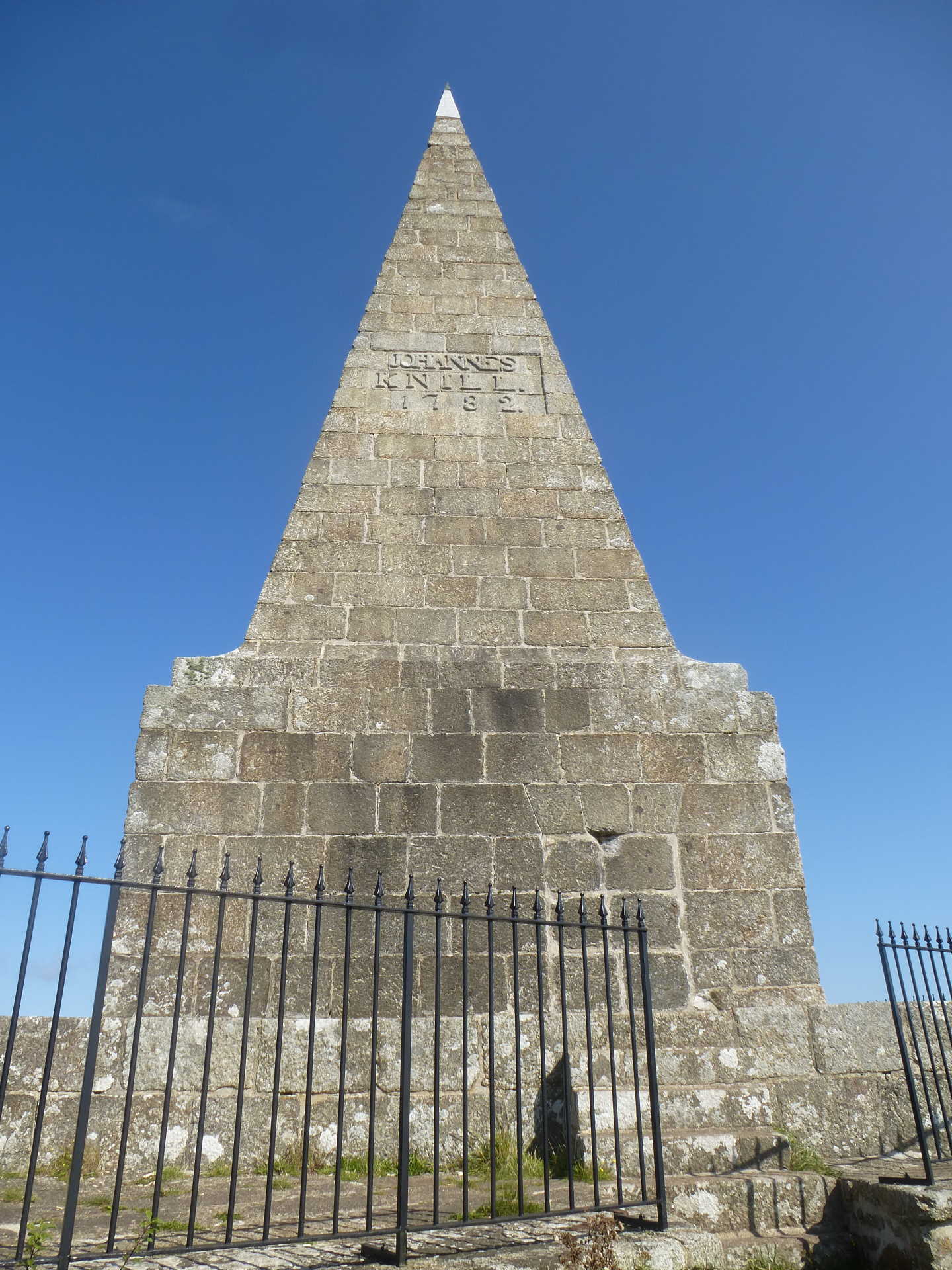
Here at the road, we want to turn right and follow until we reach The Cornish Arms. Here we need to cross the road and then take the next left and keep bearing left following the road up until we have passed the entrance to Steeple Woodland Nature Reserve. Shortly after we find a gnarly old tree and the footpath leads off to the left and takes us up to Knill's Monument on the summit of Worvas Hill. This impressive steeple style structure, built in 1782 by the slightly eccentric mayor and one time Collector of Customs of St. Ives, towers over the bay and gives wondrous views out towards Godrevy and St. Ives Bay. There is a vault within, in which Johannes Knill was to be interred, but he is instead buried in Holborn.
From here, we follow the path SW until we join a wider track which leads to the road. At this road we are going to turn left following the road past Lower and Higher Vorvas, Withen and Venwyn and then find the road bears sharply to the left. Just after this sharp turn we find a wooden signpost on our right, informing us that we have 1 ¼ miles to Trencrom, and it is this path which we are going to take, through the fenced off section of an old Holiday Park. Into the next field, the exit is diagonally across from where we enter – note, there are often horses in this field and much of the field is electric fenced, so our path may meander, but the stile is on the far side by the farm yard. Into the yard and turn left to join the road, which we want to go straight across, picking up the path which leads us alongside Standing Stone Farm and the horse stables. We enter first one field and then over the hedge where we bear right and follow the field edge up and slightly around to the left. You can see the Standing Stone off to our left.
The footpath out of this field, is to the right of the tree which sticks out and is easy to miss, so eyes open!
This footpath is now narrow and we have the bows of the trees overhead, as it winds down and at one point even appears to be in the back garden of a cottage. It comes out just in front of this cottage, where we pick up their bridleway/drive as it leads us down to the road.
Crossing over the road (take care, this is quite a busy road) we pick up the footpath as it takes us past The Bowl Rock Methodist (converted) chapel and into the field. We are going to follow the left edge of this field as it again leads us upwards, where we pick another road. Cross this final road for today, and pick up the stile on the far side (or the gate right next to it if you prefer) and we are now at the base of Trencrom Hill.
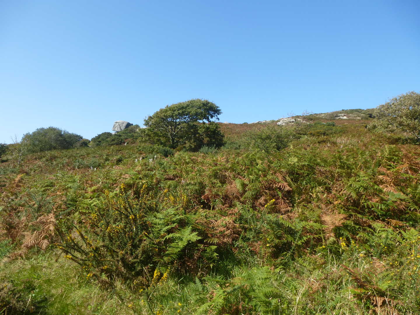
The path to the small car park follows the lower eastern edge around, but whilst here, can I suggest you take one of the numerous paths that lead up to the summit. When up here, you will find spectacular views and be able to observe the old fort that used to be here. However, also think back further as on this hill used to live a giant, a cousin to the giant of the Mount, and it is said that this giant’s hoard is buried hereabouts although heavily guarded by the Spriggans.
Once you have looked, and maybe like me had some lunch, drop back down to pick up the path that will lead us back towards the small car park. As a small note, by the small kissing gate in the bottom corner of the car park, there is a little post box, where (when Covid is not an issue) there is normally a stamp that you can use on your map to say that you are walking the St. Michael's Way.
As we head out of the car park we are going to turn right and head up the road, until we reach a minor fork (with a dead end rod sign) and here we head to the left. This takes us down towards Ninnes Bridge, where we pick up the footpath that appears to run alongside and then at the bottom of the gardens, following the stream and stepping over a stile until we step out into the field.
We take the next three fields at a diagonal, until reaching Trembethow Farm, we turn left down the track and back across the field until we reach stile in the hedge. As we step over this stile we drop down into a bridle path which heads East/West, but we are going to step across and up over the other hedge through the kissing gate. As we cross the next fields we go across a new hard-core track and straight across the middle of the next field.
This is our look out point, as it is from here that if you stand in just the right place, you can make out the three landmarks (and on a good day, possibly even St. Agnes Beacon).
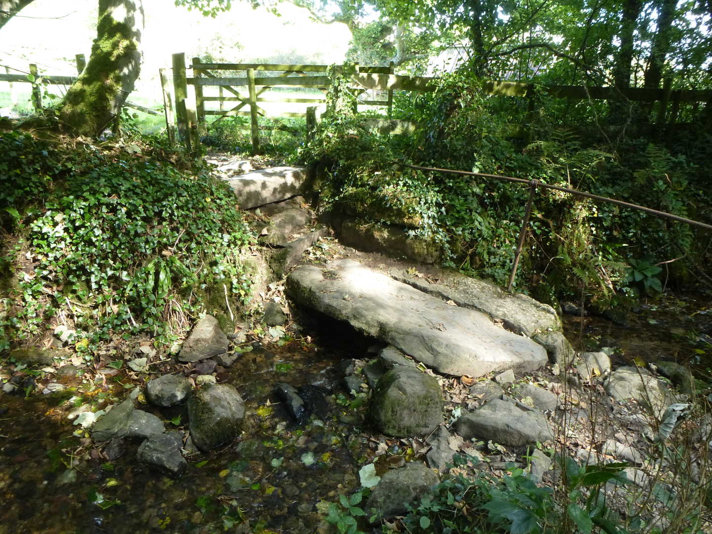
The path now starts to lead us downhill following the edge of the field, over a stile and into a small path by the trees until coming out on the road. Here we turn right and cross over a ford and at the upcoming junction we turn left and start to head up hill. Passing the houses, the road (after about ¼ mile) turns sharply left, and it is at this point that we leave the road as the footpath is on this corner and directly in front of us and with a lovely view of The Mount. Down this field we again go, until reaching another stile we step over and cross a little stream (courtesy of a granite footbridge) and then start to head up out of the trees and into a field. This field continues to take us on an uphill slant over a granite still and under some electric pylons until we reach a little cove of overhanging trees that let us emerge out onto another road.
Follow this road to the left and as we reach the hamlet of Angwinack we find a wall mounted post box on our right, and our footpath – on the same side – immediately follows. Down a little lane we go, passing over a series of granite steps before the path opens into a small field with barns on our left and another stream with a footbridge in front of us. Over the footbridge and we are back in the trees as again head up until the path picks up the bridleway that leads to Ludgvan Church. Take time to look in the community garden which is on our right.
At the Church, we are going to turn left. The St. Michael's Way has two routes here, as we could follow it to Gulval but we are going to follow to Marazion Marshes. Therefore at the Church we turn left and down until, by the houses there is a small footpath on our right that leads alongside the houses and into the field. At the bottom of this field we have to cross a small road before entering into the first of two more fields which we are going to follow the left hand edge until we again come out onto a road. At this road we turn right and follow down until we reach the main A30.
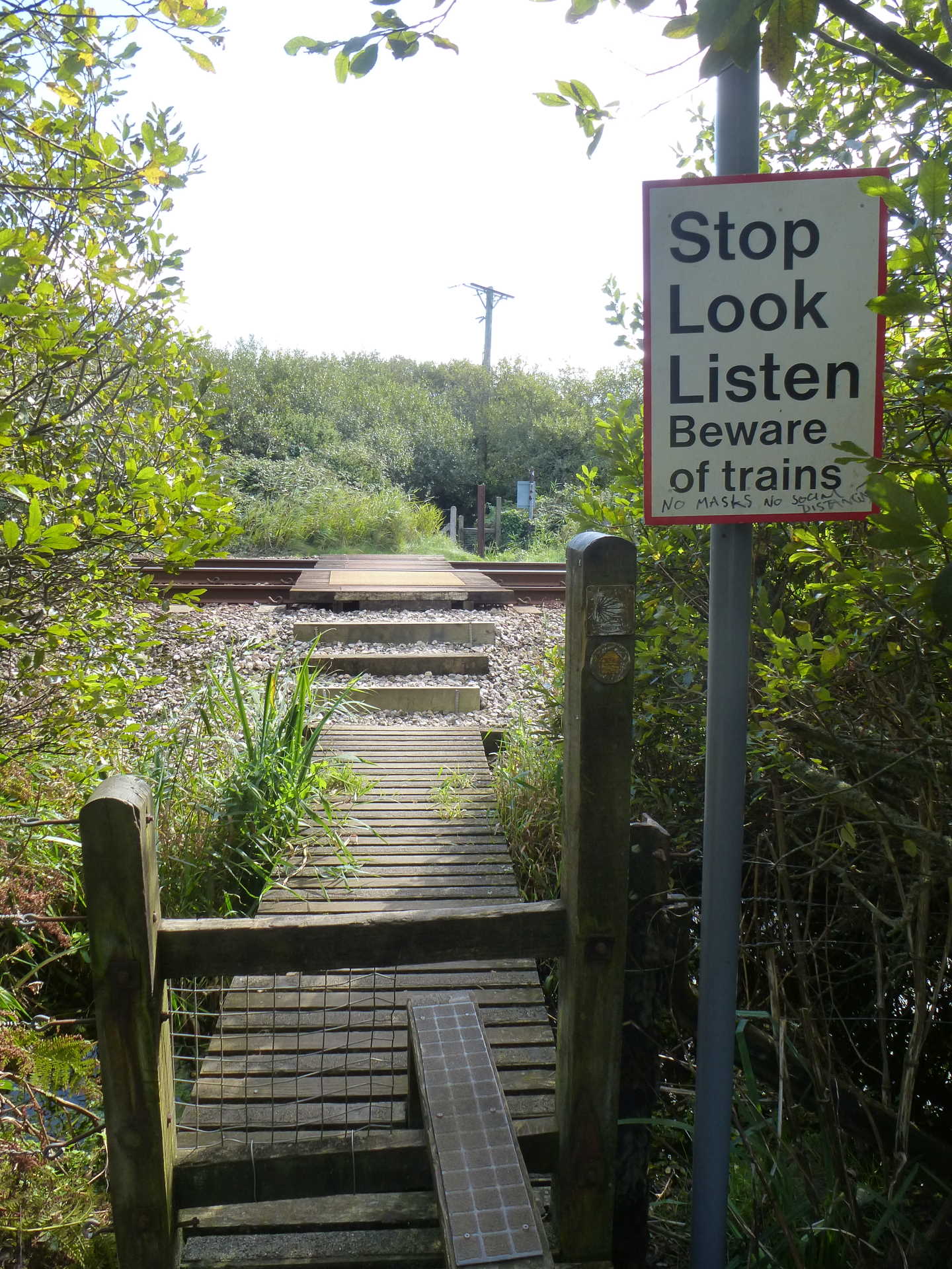
Here we need to take care as we need to cross straight over (and slightly right) this main busy trunk road to pick up the footpath back into a series of three fields of which we are going to follow the left hand edge until we again reach a road. Over this road and we are now in the trees and the beginnings of the Marshes. Here the path becomes a well laid raised wooden walkway and leads us right up to the railway tracks. Again, please great care when crossing these.
On the far side of the tracks, we again pick up the footpath and we now find that we are following the Red River as it winds its way through the Marshes and down to the granite bridge that marks the end of our walk. These marshes are a haven for bird life, so do take the time to stop and look – who knows what you might see (although the RSPB have kindly given identification markers so we can recognise much of what we see!).
We emerge from the marshes by a lovely granite bridge and from here it is a short walk to any one of the numerous car parks where we have left our second car, but with St. Michael's Mount right here or the glorious beach for a picnic – why rush away, sit for a while and enjoy the views earned from a good walk.