Lanzarote, an island for beaches and sangria and the excellent lagoon at La Santa for windsurfing. This is how many of us may first imagine Lanzarote when the name is mentioned, but picture also this;
This, essentially, low lying island with many houses no higher than two stories due to the initiative of local artist Cesar Manrique, is also known as the Island of 1000 Volcanoes. The island appears to have been formed by two series of volcanic episodes and all the volcanoes follow a North East to South West line.
The older (for the sake of argument) original volcanic episodes have left the Lanzaroteans with high mountains many of which possess calderas –the sunken central section of the volcanic crater often with one collapsed slope. These volcanoes sit amidst flat plains and vegetation has taken hold.
Then we visit the newer volcanoes, situated on the South Western end of the island. These new comers emerged from the bowels of the earth between 1730 and 1736 and are situated in the National Park of Timanfaya.
Timanfaya is the name given to the highest of these new volcanoes and stands at 510m, and is the volcano for which you can take guided tours to reach the summit –however it is NOT the biggest of the volcanoes of Lanzarote, this lies at the North East end of the island and stands at 670m and is called Penas del Chache.
For the first of my two walks in Lanzarote, I am going to start with a double circumnavigation of Calderas in the National Parkof Timanfaya. The National Park is situated between the towns of Yaiza and Tinajo and is reached by taking the road from Mancha Blanca towards La Asomada. Almost as soon as we leave Mancha Blanca we enter a volcanic landscape of sharp jagged unweathered lava flows with vast swathes of pyroclastic dust settled between like great lakes.
Just short of Montana Negra, we pull of the road and park up in one of the many free parking areas. From here, on our right we can see the start of a well laid path whichleads out into these lakes of dust and towards an impressive looking collapsed caldera, that of Caldera De Los Ceurvos. This caldera is protected by local law, so we are not allowed to climb it, but we can follow the path around picking up a number of information boards as we go. It is as we take these in (walking in an anti-clockwise direction) that we learn the reason for why I wanted to walk around this particular caldera. This was the original volcano of the newest batch of eruptions and started in 1730, and is also one of the few that have an open side to the caldera that we can walk into without climbing up and over the top rim (which we are not allowed to do).
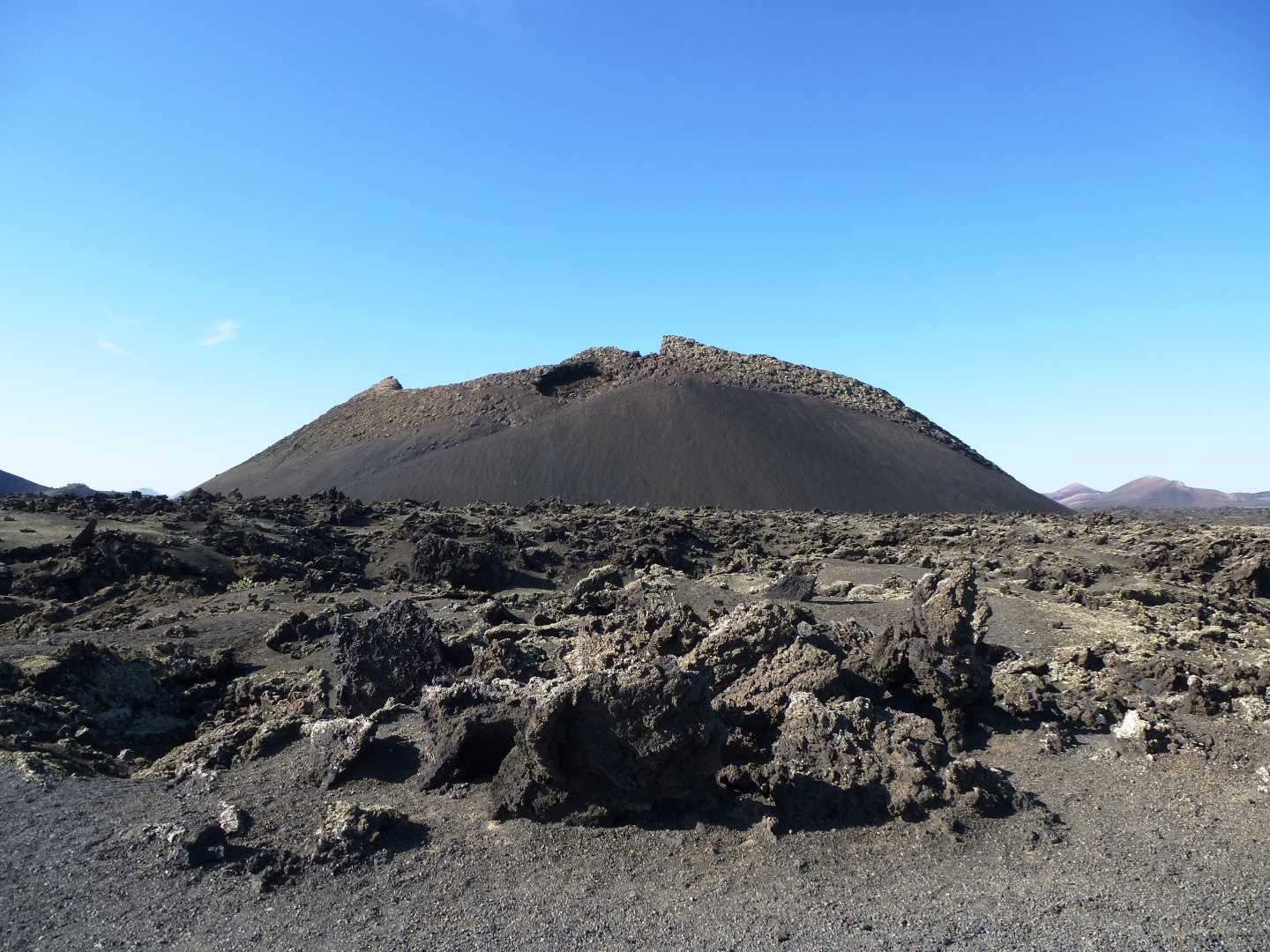
It is only once inside that we can truly imagine the power of a volcano, and the speed at which lava spews out –and cools. Indeed, all around the edges there are rock formations which look like we have just entered one of Willy Wonka`s giant toffee machines and which the Umpa Lumpas have just thrown instant cooling liquorice dust over.
Re-emerging from the crater we continue around, and as we start to head back towards the car, we find that we are on a slight slope up, on what is essentially a flat and easy 4 km walk.
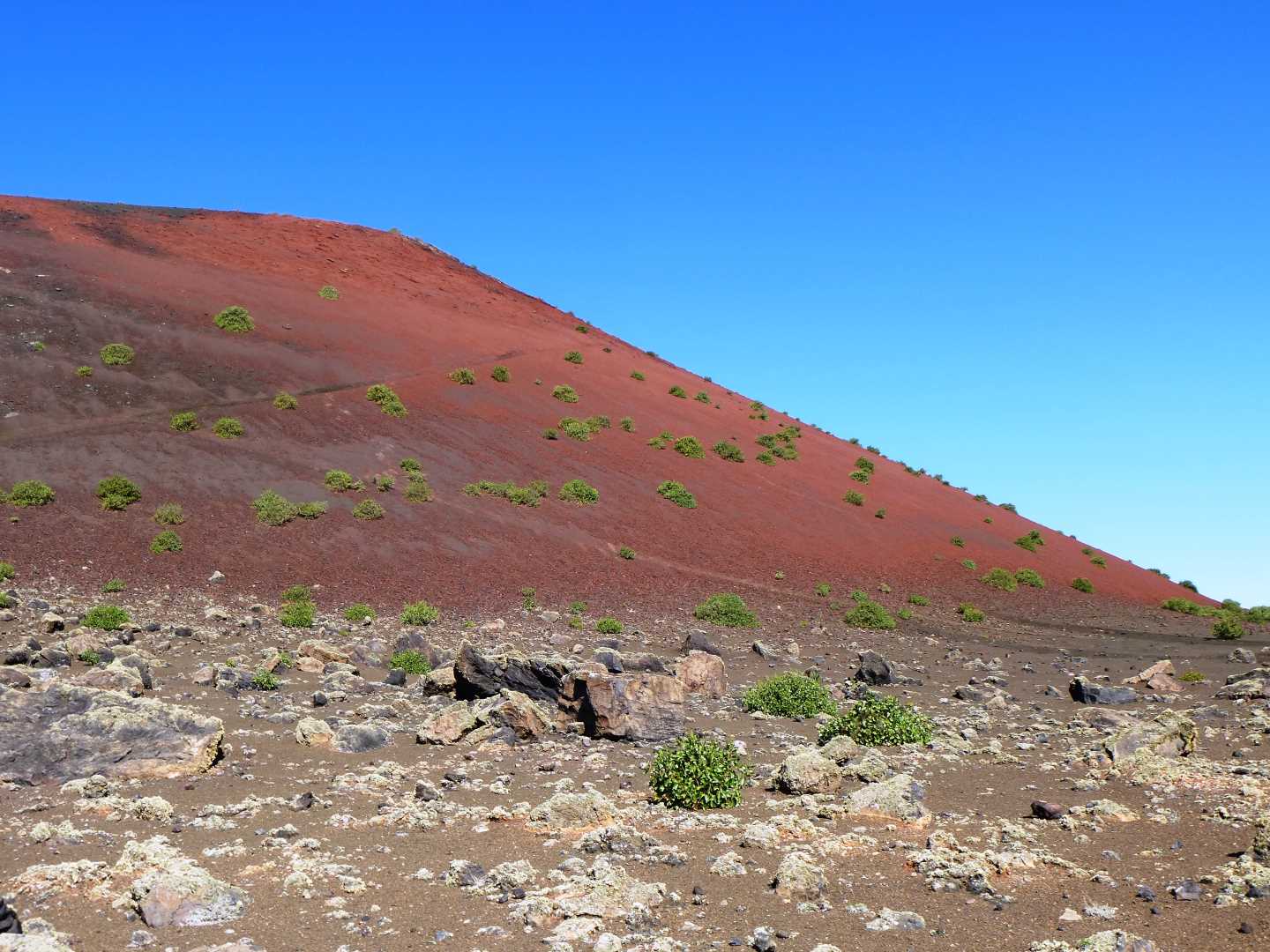
Once back at the car, we are going to walk back along the road we came on for a short distance until we reach the Montana Colorada on our right. The reason for wanting to circumnavigate this caldera is, that although close together and nestled within the boundaries of many others, this caldera was in fact the last to erupt, doing so in 1736. The walk around the outer base edge of this caldera is a short 3km, and if we walk again in an anti-clockwise direction the first half of our walk appears to have us walking around a near perfect cone of black dust. It is only when we reach the Eastern slope that suddenly the dust becomes red and as we look out to the East we see great boulders strewn about the plains as if giants have just left a massive game of marbles, mid game. It is only as we continue around to the North Western slope that we find the collapsed caldera edge, but also the quarry remains.
These quarries, which are now managed further inland on the older calderas, collected the prized volcanic dust to cover the more productive soil of the island, trapping in moisture and benefiting the local (rather good!) wine industry. In fact, when you have finished this walk, there are several artisan wineries where wine tasting can be undertaken!
From here, it is a short walk back along the road to the car and the end of the walk.
A note for the walker. Although this walk is relatively short and can be shortened and done in two stages if wanted, I found that the volcanic dust andloose lava rock was more destructive to my walking shoes on this one walk than the combined walkingof Ponta DoPico in the Azores, Kilimanjaro in Tanzania and any of the coastal paths and moors here in my beloved Cornwall!
Click here to see Part 2 of my walking in Lanzarote.